Street Element
Introduction
The Street Element of the Scottsdale Transportation Action Plan includes information and guidance to provide an efficient and multi-modal street network for automobiles, trucks, transit, bicycles, pedestrians and in some corridors, equestrians. Different strategies, such as building or widening streets, reconfiguring existing streets and applying technology, are used to improve traffic flow.
The city’s planned travel lane capacity for the arterial and collector street system is largely complete. Out of 1,061 lane miles of classified streets, approximately 51 lane miles (5%) will be left to build after the Capital Improvement Plan spanning fiscal years 2021-22 through 2025-26 is completed (see Figure S-1). Ten of those lane miles are adjacent to neighboring jurisdictions that will likely help fund future construction, and 14 of the lane miles are expected to be built by future development.

A greater number of arterial and collector street system miles are missing “complete streets” components. Complete streets provide better accommodations for non-motorized uses and add safety features such as dedicated turn lanes and raised medians. Many street segments built more than twenty years ago also lack adequate sidewalks (typically six-feet minimum width), accessible corner ramps and bike lanes, components that are now standard with street design. In all, an estimated 78 miles (12%) of sidewalks and 132 miles (21%) of bike lanes are missing from arterial and collector streets where all travel lanes have already been constructed.
Over the years, some streets were built with too many lanes based on anticipated development patterns that ultimately did not occur. On other streets, creation of the McDowell Sonoran Preserve reduced capacity needs. In all, thirty-two lane miles can be converted to non-auto uses by restriping or narrowing the street. Narrowing the distance between the outside curbs will be considered when the remaining travel lanes will continue to operate at 75% or less of capacity (7,500-10,000 vehicles per lane per day, depending on number of lanes, land use and access conditions).
The Street Element supports creating a safe and efficient roadway system. As the street system continues to age, preventive maintenance and repair and/or replacement of pavement, concrete, traffic signals and streetlights will need to be prioritized.
Goals
- Emphasize traffic safety, livable streets and multi-modal community access over rapid traffic throughput.
- Develop and manage the street network in a manner that places reliance on maintaining existing infrastructure and improving the efficiency of the existing system before adding new roadway capacity.
- Maintain and improve multi-modal circulation by narrowing roadways where appropriate; including alternative modes of transportation when widening roadways; using existing and future Intelligent Transportation Systems technology and access control to manage traffic flow; and identifying major and minor intersections for capacity and safety improvements.
- Provide a framework for the development of a transportation system for Scottsdale that is based on the complete streets concept, where streets are designed and constructed in a manner that supports comfortable usage by all travel mode types
- Minimize heat island effects by reducing existing pavement where traffic demand is less than previously planned and experimenting with paving technologies, including consideration of cool (white) pavement, that support sustainability and/or reduce daytime heat absorption and nighttime heat radiation.
Policies
Complete Streets: Provide sufficient right-of-way and design, operate, and maintain Scottsdale's streets to promote safe and convenient access and travel for users of all types: pedestrians; mobility assisted; bicyclists; transit vehicles and riders; equestrians; cars; and trucks. Provide facilities and amenities that are recognized as contributing to complete streets, including roadway and pedestrian level street lighting; pedestrian and bicycle safety improvements; access improvements in accordance with ADA; transit facilities accommodation, including but not limited to pedestrian access improvement to transit stops; street trees and landscaping; and street furnishings that are sensitive to the local context.
Traffic Safety: Collect, analyze and report on traffic collision data on a regular basis and develop remediation measures to address high frequency and high volume collision locations.
Roundabouts: Roundabouts shall be the first consideration for all intersections of one- or two-lane-per-direction streets that require all-way stop control. Traffic signals should only be installed or remain if a traffic or budget analysis justifies their advantage.
Roadway Restriping: Improve on-street bicycle accommodation and bicycling and pedestrian comfort through striping changes that consider historic and forecasted motor vehicle traffic, center turn lane requirements, existing pavement width and existing lane widths. This restriping protocol will typically be applied when roadways are being treated through standard pavement preservation applications and will incorporate buffered bike lanes where feasible.
Neighborhood Traffic Management: Protect Scottsdale’s residential neighborhoods from excessive vehicle travel speeds and cut-through traffic.
Truck Routes: All planned four lane or larger streets are considered truck routes, unless noted as an exception. Neighborhood/local system routes will not be considered for truck route designations.
Intelligent Transportation Systems (ITS): Support the ITS strategic plan to coordinate signals; integrate freeway and arterial operations; improve traffic progression; reduce incident clearance times; and enhance special event traffic management. Also recognize the need to balance traffic flow with improved pedestrian, bicycle and transit flow on some corridors.
Access Management: Define acceptable levels of access for each roadway classification to preserve its function, including criteria for the spacing of signalized and unsignalized access points. Apply and enforce appropriate geometric design criteria and traffic engineering analysis to each allowable access point. Specific access management criteria shall be included in the City’s Design Standards & Policies Manual (DS&PM), which is updated on a regular basis and approved by the city’s Design Review Board.
Roadway Character Types: Identify roadway corridors as either urban, suburban or rural. Urban street areas are located in Old Town Scottsdale, where pedestrian activity is likely to be the highest and alternative modes of transportation are more likely. Suburban street areas often have separation between residential and commercial or employment uses. Generally, the suburban designation is for roadways south of Pinnacle Peak Road. Rural street areas are desert or low-density land use areas here commercial and employment activities are more limited, and equestrian activity is greater. Generally, roadways north of Pinnacle Peak Road are identified as rural.
Roadway Noise Abatement: Roadway noise levels considered for mitigation shall be consistent with the Arizona Department of Transportation’s 2017 Noise Abatement Requirements. The ADOT standards are required by Federal law (Code of Federal Regulations – 23 CFR 772) to match the Federal Highway Administration’s noise standards. These standards consider noise abatement when there is an increase of 15 decibels (dBA) in the model-predicted roadway noise levels over existing noise levels occur and/or the predicted noise level is at or above 67 dBA.
Street System/Functional Classification
The street system consists of a hierarchy from local streets (smallest capacity) to collector streets to arterial streets (largest capacity). These functional classes establish a common understanding of the use of the street and its character, regulate access from adjacent properties and determine how the costs of new street construction are shared between the city and surrounding properties. Location within areas of the city designated as Environmentally Sensitive Lands (ESL) is also a factor in street classifications.
Over the years, the three functional classes have evolved into a set of 20 sub-classifications as shown in Table S-1. Only the arterial and collector categories are identified on published maps. The character designations (rural, suburban and urban) are determined during the design review process. Location within areas of the city designated as Environmentally Sensitive Lands (ESL) is also a factor in roadway classifications.
| Street Type | Character Designation |
|---|---|
| Major Arterial | a) rural, b) suburban, c) urban |
| Minor Arterial | a) rural/ESL, b) suburban, c) urban |
| Major Collector | a) rural/ESL, b) suburban, c) urban |
| Minor Collector | a) rural/ESL with trails, b) rural/ESL c) suburban, d) urban |
| Local Collector | a) rural/ESL with trails, b) rural/ESL c) suburban |
| Local Residential | a) rural/ESL with trails, b) rural/ESL c) suburban |
Major and Minor Arterials
Arterial streets have raised medians, provide regional continuity and provide for long-distance traffic movements. Coordinating regional networks maintains continuous and useful links between Scottsdale and its neighbors. Major arterials stress traffic movement while minimizing local access. Minor arterials also stress traffic movement, but moderate access is provided to adjacent land uses. Access is controlled primarily through the raised medians, as well as by the spacing and location of driveways and intersections. Arterial streets generally serve higher traffic volumes (20,000–55,000 average daily trips [ADT]) than collector streets.
Major and Minor Collectors
Collector streets provide for shorter distance traffic movements and connect arterial and local streets. Collectors serve medium traffic volumes (5,000–32,000 ADT) and balance prioritizing access to adjacent commercial and residential land uses and travel efficiency.
Local Collector, Residential and Commercial/Industrial Streets
Local streets provide direct access to adjacent land uses, provide access to the collector street system and accommodate lower traffic volumes (usually less than 5,000 ADT) and travel speeds. Traffic calming can be considered on local streets.
Street Classifications
Figure S-2 presents the recommended functional classification system for all arterial and collector streets in the city. Arterials and collectors are also designated as either major or minor. Minor collectors are further designated as having a center turn lane or not. The number of lanes ranges from two on a minor collector to six on a major arterial.

Table S-2 lists planned changes to street classifications and Table S-3 lists minor collector segments that would not require a center turn lane.
| Street | From | To | 2016 Classification | 2022 Classification |
|---|---|---|---|---|
| 64th St. | Jomax Road | Dynamite Blvd. | Major Collector | Minor Collector |
| 92nd St. | Raintree Drive | Frank Lloyd Wright Blvd. | Major Collector | Minor Collector |
| 96th St. | Via Linda | Shea Blvd. | Major Collector | Minor Collector |
| 100th St. Loop | Frank Lloyd Wright Blvd. | Frank Lloyd Wright Blvd. | Major Collector | Minor Collector |
| 128th St. | 1,320' north of Ranch Gate Road | Jomax Road Alignment | Minor Collector (no center lane) | Emergency Access only |
| 130th/132nd St. | Shea Blvd. | Via Linda | Major Collector | Minor Collector |
| Bell Road | Thompson Peak Parkway | McDowell Mountain Ranch Road | Minor Arterial | Minor Collector |
| Drinkwater Blvd. | Scottsdale Road | Scottsdale Road | Couplet | Minor Arterial |
| Goldwater Blvd. | Scottsdale Road | Scottsdale Road | Couplet | Minor Arterial |
| Hayden Road | McKellips Road | Indian School Road | Major Arterial | Minor Arterial |
| Legend Trail Parkway | Pima Road | Stagecoach Pass | Major Collector | Minor Collector |
| McCormick Parkway | Scottsdale Road | Hayden Road | Major Collector | Minor Collector |
| McDowell Mountain Road | 105th St. | Bell Road | Minor Arterial | Minor Collector |
| Osborn Road | 68th St. | Scottsdale Road | Major Collector | Minor Collector |
| Raintree Drive | Thompson Peak Parkway | Frank Lloyd Wright Blvd. | Major Collector | Minor Collector |
| Redfield Road | Raintree Drive | Frank Lloyd Wright Blvd. | Major Collector | Minor Collector |
| Thunderbird Road | 89th St. | Frank Lloyd Wright Blvd. | Major Collector | Minor Collector |
| Westland Drive | Scottsdale Road | Hayden Road | Minor Arterial | Minor Collector |
| Street | From | To |
|---|---|---|
| 68th St. | Camelback Road | Chaparral Road |
| 78th St. | Mountain View Road | Shea Blvd. |
| 78th St. | Jackrabbit Road | McDonald Drive |
| 84th St. | Shea Blvd. | Thunderbird Road |
| 90th St. | Cactus Road | Thunderbird Road |
| 92nd St. | Sweetwater Ave. | Thunderbird Road |
| 100th St. | Cactus Road | Camino del Santo |
| 104th St. | Shea Blvd. | Sweetwater Ave. |
| 108th St. | Via Linda | Cactus Road |
| 110th St. | Mountain View Road | Cholla St. |
| 110th St./Altadena | Cholla St. | Frank Lloyd Wright Blvd. |
| 124th St. | Mountain View Road | Shea Blvd. |
| 128th St. | Pinnacle Peak Road alignment | 1,320' north of Ranch Gate Road |
| 128th St. | Jomax Road alignment | Rio Verde Drive |
| 130th St. | Southern terminus | Shea Blvd. |
| 136th St. | Dynamite Blvd. | Lone Mountain Road |
| Camelback Road | 82nd St. | Granite Reef Road |
| Chaparral Road | 66th St. | Scottsdale Road |
| Dove Valley Road | 60th St. | 64th St. |
| Eastwood Lane/Via de Ventura | Scottsdale Road | Doubletree Ranch Road |
| Granite Reef Road | Thomas Road | Osborn Road |
| Granite Reef Road | McDonald Drive | Arizona Canal |
| Grayhawk Drive | Scottsdale Road | Hayden Road |
| Jackrabbit Road | Quail Pl. | Scottsdale Road |
| Jackrabbit Road | Miller Road | Hayden Road |
| Miller Road | Shea Blvd. | Cactus Road |
| Miller Road | Chaparral Road | Jackrabbit Road |
| Mountain View Road | 117th Way | 124th St. |
| Oak St./Murray Lane | Miller Road | Granite Reef Road |
| Osborn Road | 64th St. | 68th St. |
| Paradise Lane | 98th St. | Thompson Peak |
| Pinnacle Peak Road | 92nd/93rd St. | Via Ventosa |
| Raintree Drive | Frank Lloyd Wright Blvd. | 100th St. |
| Ranch Gate Road | 118th St. | 128th St. |
| Roosevelt St. | Scottsdale Road | Hayden Road |
| Roosevelt St. | Granite Reef Road | Latham St. |
| Sweetwater Ave. | Scottsdale Road | Hayden Road |
| Sweetwater Ave. | 90th St. | Frank Lloyd Wright Blvd. |
| Thunderbird Road | Hayden Road | 84th St. |
| Via Linda | Via de Ventura | Loop 101 underpass |
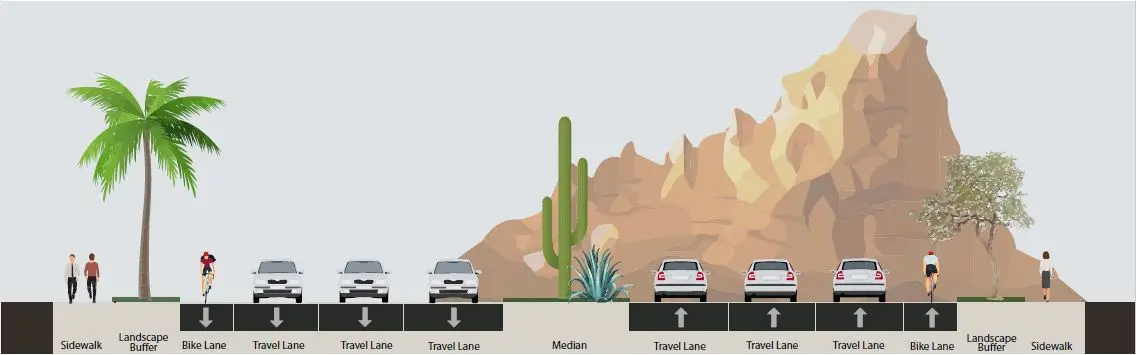
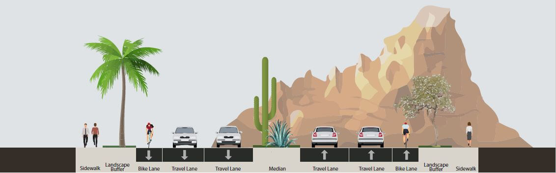
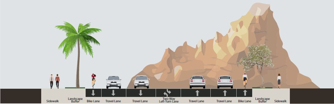
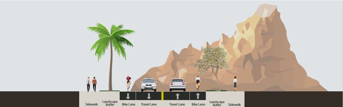
Cross Section Models
Figures S-3 through S-7 are graphical representations of the typical cross section for each street type.

Right-of-Way
Typical right-of-way requirements are provided in the DS&PM cross section examples. However, many street segments have had varying classifications over time. As a result, Figure S-8 is provided to identify the recommended right-of-way dedication widths for all streets classified as minor collector and larger on the Street Classification Map. The recommended widths are intended to provide a consistent outside edge of right-of-way that matches previous dedications and acquisitions, as well as to maintain consistency with the city’s Scenic Corridor Design Guidelines (2003). These dimensions are stated for the street segments only. At intersections, a larger dimension may be necessary to accommodate turning lanes.

Performance Measures
- Reduce citywide intersection and roadway segment collision rates, based on six-year moving averages.
- Maintain existing streets to a citywide “Very Good” pavement condition index (70-85).
- Maintain vehicular level of service (LOS) D or better at most signalized intersections, except in designated activity cores or urban roadway corridors where walkability, transit access, and aesthetic or right-of-way considerations are overriding.
- Use Maricopa Association of Governments data to monitor average roadway travel times and assess the feasibility of mitigation strategies when a trip takes 30% longer in peak travel times than during non-peak times.
- Target average daily traffic volumes on collector streets 7,500-9,000 vehicles per lane per day using 2040 forecasted volumes.
- Target average daily traffic volumes on arterial streets to no more than 8,500-10,000 vehicles per lane per day using 2040 forecasted volumes.
- Maintain a positive (excellent/good) rating of 70 percent or better in the National Community Survey for “Ease of Travel by Car.”
Last Updated: May 21, 2026