Pedestrian Element
Introduction
Scottsdale's sidewalks and enhanced crossings provide a network for people walking, skating and using personal assistive mobility devices. The Pedestrian Element will assess priorities to make Scottsdale more walkable and provide safe, convenient, barrier-free pedestrian ways and facilities that promote walking short distances. For example, shade along sidewalks and bus stops can make walking and transit use much more comfortable.
Specific sidewalk standards are found in the Design Standards and Policies Manual (DS&PM) Street Geometrics and Public Pedestrian Facilities sections. The TAP Streets Element provides cross sections by functional classification [will link] with guidance similar to that in the DS&PM. The cross sections outline sidewalk placement, which vary by functional classification and character areas.
One significant change to the pedestrian element in the 2022 TAP is a new policy to locate shade trees on the west side of north/south streets and on the north side of east/west streets on the side of the sidewalk, opposite the street. Previously shade trees were placed between the sidewalk and the street. The new orientation provides the most shade for pedestrians during the hottest months of the year.
Goals
- Build and maintain pedestrian facilities that form a continuous and interconnected network with seamless connections to public transit, schools, neighborhoods and community destinations.
- Provide pedestrian amenities, promote land uses and encourage private efforts that enhance public spaces, neighborhoods, commercial and employment areas.
- Implement education, encouragement and data collection programs to increase walking and reduce the number and severity of pedestrian crashes.
- Create and improve pedestrian access between neighborhoods and to transit routes.
- Maintain and enhance the current pedestrian network to meet current design standards.
- Provide pedestrian/cycling enhanced crossings where appropriate.
Policies
- Construction Priorities: Prioritize use of capital improvement funds to complete projects that address accessibility concerns, network gaps, school and/or transit access and reductions in neighborhood barriers.
- Roadside Landscaping: Orient shade tree placement to maximize shade on the sidewalk during the summer months (west of west-side sidewalk on north/south roads, north of north-side sidewalk on east/west roads).
- Roadway Restriping: Improve pedestrian comfort through striping changes that provide greater separation from vehicles though the installation of new bike lanes, wider bike lanes or buffered bike lanes.
- Neighborhood Barriers: Reduce the length of continuous perimeter walls to encourage pedestrian connectivity to collector and arterial streets and shared use paths and transit connections.
- Enhanced Pedestrian Crossings: Develop and use the Guidelines to Identify Pedestrian Crossing Treatments to support grade separations, pedestrian signals and other crossing enhancements.
- Intelligent Transportation Systems (ITS): Identify and test solutions that balance traffic flow with improved pedestrian mobility in key corridors.
- Safety: Work with public safety staff to improve enforcement of traffic laws related to pedestrians. Collect, analyze and report on pedestrian collision data on a regular basis and develop remediation measures to address high-frequency and high-volume collision locations. Support Safe Routes to School programs.
Sidewalk Cross Section
Trees are located on the west or north side of the sidewalk to provide maximum shade during hotter times of the year. In previous plans, trees were located between the sidewalk and the curb on both sides of the street. Lower growing landscaping will typically remain in a 3 to 4 foot buffer between the sidewalk and curb. Figures P-1 and P-2 below show locations where the cross sections changed, indicated by yellow areas.
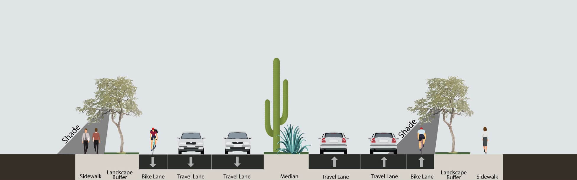
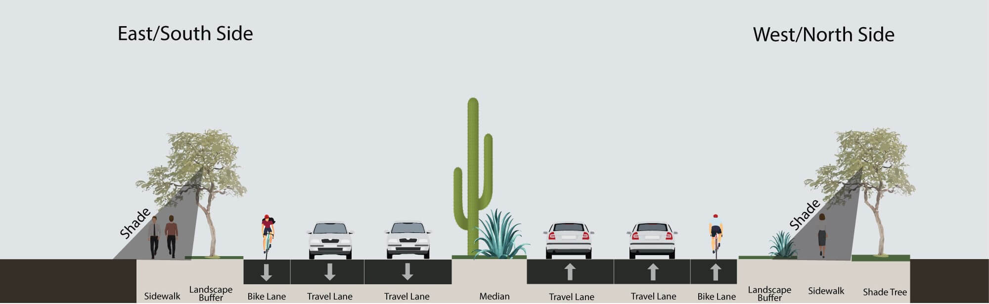

In areas where sidewalks are less likely to experience high volumes of pedestrians due to lower density and/or subdivision access restrictions, one side of four-lane and six-lane streets has a narrower sidewalk of six feet, while maintaining an eight-foot-wide sidewalk on the other side. The wider sidewalk also serves as a side path for bicyclists. Some roads are planned to have a 10-foot multi-use path in place of a sidewalk to provide regional non-motorized connections to the city of Phoenix.
Accessibility
The 2021 draft Scottsdale Americans with Disability Act (ADA) Self-Evaluation and Transition Plan Update prioritizes areas for improvements for pedestrians along streets and transit routes (shown in Figure P-4). Additional ADA improvements will continue to be included on streetscape, pavement maintenance

Enhanced Crossings
Trends show that we are more active than previous generations. With the movement towards livable communities, walking and biking are becoming more attractive to enhance the quality of life. Enhanced crossings are integral in accomplishing connectivity and safety and promote the health, livability and equity of a community. There are two main categories of enhanced crossings: grade separated and at-grade crossings. Criteria such as sight distance, proximity to intersections, traffic volumes, roadway cross section and nonmotorized volumes are used to determine what type of crossing is appropriate at a given location.
Enhanced bicycle, pedestrian and equestrian crossings provide safer connectivity at various locations including intersections, physical barriers and high nonmotorized activity areas. Enhanced crossings also provide regional connectivity, transit access and ADA accessibility. Types of enhanced crossings include bridges, tunnels, pedestrian refuge islands, raised pedestrian crossings, high intensity activated crosswalks (HAWKs) and rectangular rapid flashing beacons. Currently, there are 219 enhanced crossings in Scottsdale ranging from raised pedestrian crosswalks to tunnels and bridges.
As shown in Figure P-5, enhanced crossings are more prevalent in central and southern Scottsdale due to the context of the built environment. Central and southern Scottsdale has an urban and dense environment compared to northern Scottsdale, which has a suburban and low-density environment. A myriad of opportunities remain in central and southern Scottsdale to integrate enhanced crossings. A pedestrian refuge is the most commonly implemented enhanced crossing in Scottsdale because it serves neighborhoods and is cost-effective.

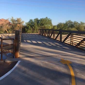
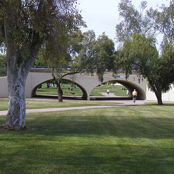
Grade-Separated Crossings
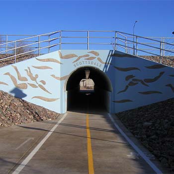
A grade-separated crossing is a bridge, underpass or tunnel that allows nonmotorized traffic to avoid any interaction at street crossings, intersections or a physical barrier. Grade separated crossings are encouraged where paths and trails intersect major streets or canals.
Grade-separated crossings should be required with new construction where major roadways cross a trail or path. Design of new drainage culverts should accommodate a path and trail and consider the needs of bicyclists, pedestrians and equestrians.
Examples of grade-separated crossings are shown in Figure P-6.
At-Grade Crossings
Where grade-separated crossings are not viable or necessary, at-grade crossings can be used. In many locations and for many reasons, grade separation and/or signalization may not be feasible or warranted. Several specific treatments can be incorporated at designated crossings that give path and trail users a greater sense of security, comfort and convenience.
Signalized At-grade Crossings
In the absence of a grade-separated crossing, a signalized crossing should be considered if warranted, according to the Manual on Uniform Traffic Control Devices (MUTCD). Examples of signalized crossings include a Rectangular Rapid Reflecting Beacon or High Intensity Activated Crosswalk (HAWK) (see Figure P-7).
.jpg?sfvrsn=7c1a9c18_1)
Unsignalized At-Grade Crossings
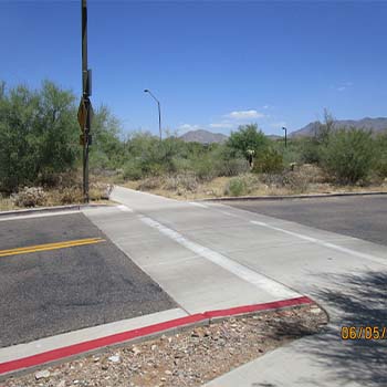
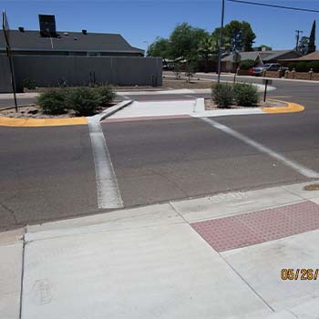
Unsignalized at-grade crossings are considerably less costly than grade-separated crossings. Streets with many lanes, higher traffic speeds and higher traffic volumes would better accommodate bicyclists and pedestrians with the use of a greater number of design treatments such as a Raised Pedestrian or Pedestrian Refuge (see Figure P-8).
Future Enhanced Crossings
Scottsdale recently developed Guidelines to Identify Pedestrian Crossing Treatments to assist in determining what type of crossing is appropriate for an identified location. The document incorporates recommendations from state and federal transportation agencies, provides a standardized process to evaluate new crossing locations and provides criteria and considerations for establishing a new enhanced crossing.
In addition to using established guidelines for the installation of new enhanced crossings, Scottdale continues to be proactive in the planning and future capital programming of three identified locations that are critical for regional connectivity. These locations are a bridge over the Loop 101 along the Central Arizona Project Canal, an underpass at Bell Road within the Reata Wash to provide connectivity between WestWorld and Scottsdale's McDowell Sonoran Preserve and an underpass at Loop 101 at the Mayo Boulevard alignment (see Figure P-9). Priority corridors for future grade separations are Scottsdale Road, Pima Road, Frank Lloyd Wright Boulevard and Shea Boulevard.

Performance Measures
- Reduce citywide per capita pedestrian collision occurrences, based on six-year moving average data.
- Complete pedestrian improvements identified as Priority Areas in the ADA Self-Evaluation and Transition Plan Update within five years.
- Maintain a positive (excellent/good) rating of 80 percent or better in the National Community Survey for “Ease of Walking.”
- Percentage of arterial and collector roadway miles with sidewalks that meet current design standards.
- Percentage of population within ¼ mile network walking distance to a collector or arterial street.
Last Updated: May 21, 2026