
Trails Master Plan
What is it?
Two documents that guide the planning and provision of unpaved trails and work in tandem to achieve the overall goal of creating a citywide network of interconnected trails for use by multiple non-motorized user groups. The Conceptual Trails Plan for the McDowell Sonoran Preserve, accepted by the City Council in 1999, controls the provision of trails within the boundary of the McDowell Sonoran Preserve. The Trails Master Plan, approved by the City Council in 2004, guides the provision of trails within the City outside the Preserve.
City Council accepted - 1999; City Council Adopted - 2004
Where does it apply?
The Trails Master Plans include a total of 650 miles of trails. These trails may be located on publicly owned property such as the McDowell Sonoran Preserve, park land, or public rights-of-way, or may be located within public trail easements that pass through private property.
Who needs to use it?
City staff use the Trails Master Plan to establish requests for public trail easement dedications and/or trail improvements from private developers, and to guide the provision of trails on publicly owned (non-Preserve property). The Conceptual Trails Plan for the Preserve is used by City staff to guide the construction of trails within the boundary of the McDowell Sonoran Preserve. Private landowners and the development community can use both plans to advance their understanding of where future public trails are likely to be located.
Why was it developed?
Both the Trails Master Plan and the Conceptual Trails Plan for the Preserve were prepared to provide a comprehensive guide to the provision of an interconnected trail system.
Key Points:
- The goal is to create a seamless network of unpaved trails that link neighborhoods to destinations including the McDowell Sonoran Preserve.
- Trails are created so as to minimize disturbance to the natural environment.
- Trails create close-to-home recreational opportunities.
- Trails promote knowledge and understanding of the Sonoran Desert Environment.
- The trail system provides opportunities for physical activity resulting in improved mental and physical health.
- The three primary trail user groups are hikers, bicyclists, and equestrians.
- Motorized vehicles are prohibited (per Ord. 17-62) from using Scottsdale’s public trails.
Where is the full policy located?
- Transportation Department Library - Suite 205
- Community Design Studio - Planning and Design Library
References and related documents:
Contact Information
City of Scottsdale - Transportation
7447 E. Indian School Rd., Suite 205
Scottsdale, AZ 85251
P: 480-312-7250
TDD: 480-312-5419
F: 480-312-4000
Traffic Engineering
P: 480-312-7250
Street Operations
P: 480-312-5620
Traffic Management Center
P: 480-312-7777 (6 a.m. - 6 p.m. weekdays)
[email protected]
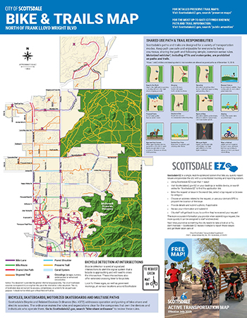
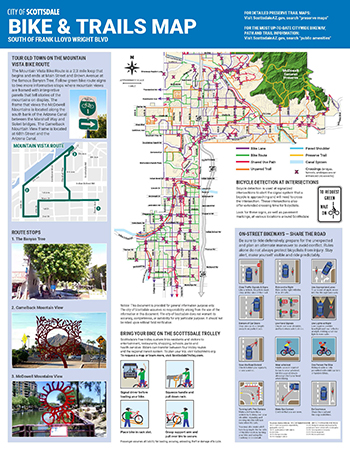
Active Transportation Map
Scottsdale’s Active Transportation Map showcases the city’s trails and bikeways. The waterproof, tear-proof map can be found at Scottsdale libraries, bike shops and community centers, or it can also be delivered to your home for free. Contact Jessica Baux at [email protected] or 480-312-1770 to order your copy now.
New! Download a geo-referenced pdf map compatible with the Avenza Maps App .
.