
Scenic Corridors & Streetscapes
What is it?
 Scenic Corridors (created with 1-GP-2004 General Plan amendment) are major thoroughfares designated by the General
Plan to have scenic desert landscape setbacks , providing a sense of
openness for the community. The Design Guidelines provide an outline
of the city's design expectations for all designated Scenic Corridors.
Scenic Corridors (created with 1-GP-2004 General Plan amendment) are major thoroughfares designated by the General
Plan to have scenic desert landscape setbacks , providing a sense of
openness for the community. The Design Guidelines provide an outline
of the city's design expectations for all designated Scenic Corridors.
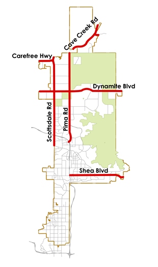
Where Does It Apply?
- Carefree Highway (west from Scottsdale Road to the City’s western Boundary – 2 miles)
- Cave Creek Road (northeast of Pima Road to the City’s northeast boundary -- 3.5 miles)
- Dynamite Boulevard (east from 56th Street to the City’s eastern boundary -- 10.5 miles)
- Pima Road (north of the 101- Loop to Cave Creek Road -- 11 miles)
- Scottsdale Road (north from Frank Lloyd Wright to Carefree Highway – 11 miles)
- Shea Boulevard (Pima Freeway east to the City’s eastern boundary – 9 miles)
Why Was It Developed?
- Executive Summary (PDF)
- Guidelines (PDF)
- Proposed Additions
To preserve or restore the natural desert setting along the roadway and to buffer the landowners from adverse affects of adjacent roadway traffic. To provide travelers with views of nearby mountains, washes and other natural features. For connectivity of pedestrian, equestrian and bicycle ways buffered from traffic by a desert setting. To support our economic tourism industry's image by providing key passages displaying our lush Sonoran Desert.
Key Points:
- Scenic Desert Landscape Setback-- Minimum 100' from back of Right of Way. Exceptions may apply to single family residential.
- Scenic Desert Landscape Setback secured by easement through development process. Easement to include non-vehicular access for trial/path/walk.
- No development improvements in Scenic Desert Landscape Setback.
- Any required improvements (civil /safety/etc .) designed to blend into and mitigate impact on natural desert (consistent with Concepts of the Great Sonoran & Sensitive Design Principles).
- Utilities preferred underground. Above grade street hardware/related components follow designated material/color palate.
- Scenic Desert Landscape Setback may be counted as required open space and in most cases as N.A.O.S.
- Multi-use paths/walks/trails are to run through Scenic Desert Landscape Setback buffered a minimum of 1 0' from roadway and should return to road at all intersections, drives and transit stops.
- Two allowed landscape characters a) Preserved Natural or Revegetated to natural state 2) Structured use of natural desert plant pallet for commercial- high activity areas.
- No detention basins in scenic easement. Drainage facilities limited to regional flows.
- Development edge (walls and buildings) should be low rolling horizontally and vertically with the topography. Materials and colors of deep tones and textures to blend into desert.
Streetscape Design Guidelines:
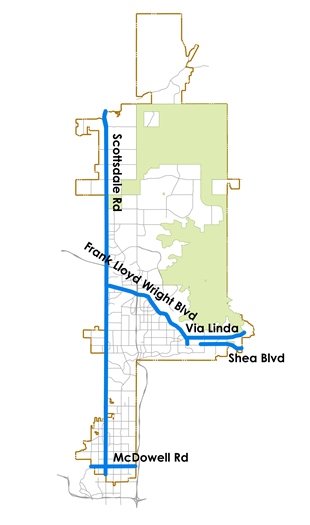 East Shea
- Expressway Policy (PDF)
- Frank Lloyd Wright Boulevard
- Via Linda
- McDowell Road Streetscape Guidelines (PDF)
- Scottsdale Road Streetscape Guidelines (PDF)
- Additional Area Resources
The Scenic Corridors Design Guidelines are a part of the City of Scottsdale’s Sensitive Design Program. The Scottsdale Sensitive Design Program is a comprehensive compilation of policies and guidelines related to the City's built environment. The basic framework for these policies and guidelines are the Scottsdale Sensitive Design Principles, initially approved by the Development Review Board in 2000. The Principles, derived from existing city policies and from concepts developed by citizen groups such as Great Sonoran, articulate Scottsdale's design vision and outline design expectations and values. Like all City of Scottsdale design guidelines, the Scenic Corridor Design Guidelines are polices and should not be construed as ordinance.
These policies are standards, details, and concepts that are to be used to establish the health, safety, welfare, quality and character of physical improvements within the city. These policies also create the basis for visual character within and along certain major roadways having a particular emphasis on retaining and displaying the native desert and traditional southwest cultural heritage of the area.
The guidelines provide an outline of the City’s design expectations for all designated Scenic Corridors, and are intended to be used by all participants in the development process including citizens, policy makers, design professionals, and developers.
Scenic Corridor Vision Statement:
Scottsdale citizens value the natural desert setting along the northern and eastern portions of major thoroughfares in our community. There is an understanding by the community at large that these should be preserved or recreated as meaningful open space. The City’s General Plan reflects this commitment by designating portions of Scottsdale Road, Pima Road, The Carefree Highway, Cave Creek Road, Dynamite Boulevard, and Shea Boulevard as Scenic Corridors.
Recognizing the value of community character, on the behalf of our citizens, the City of Scottsdale has pledged to take certain steps to protect this valued resource of natural linear open space from rapidly approaching development. Those steps include:
- Constructing new, expanding existing, and over time, retrofitting existing roadways designated as Scenic Corridors so that the design policies and guidelines found in this document are carried out.
- Working to restore and maintain the natural beauty of the Sonoran Desert within the scenic desert landscape setbacks along these corridors of regional significance.
- Applying the design policies and guidelines found in this document to public and private development on both edges of these corridors.
- Educating staff, policy makers, and the public about the existence, goals and benefits of Scenic Corridors in their community.
Contact Information
City of Scottsdale – Long Range Planning
7447 E. Indian School Road, Scottsdale, AZ 85251
P: 480-312-7000
Email: [email protected]
Adam Yaron
Planning & Development Area Manager
P: 480-312-2761
Email: [email protected]
Taylor Reynolds
Principal Planner
P: 480-312-7924
Email: [email protected]