
Reata Wash Flood Control Study
The Reata Wash floodplain encompasses a large area in north Scottsdale between approximately Pinnacle Peak Road and the Central Arizona Project Canal. Approximately 30 years ago, the Federal Emergency Management Agency (FEMA) defined the 100 year Reata Wash floodplain based on the potential flood hazards identified. There are more than 4,600 residential, public facilities and commercial structures located within the floodplain at potential risk of flooding.
In 2014, the City of Scottsdale initiated a flood control study to identify and recommend flood control measures that will reduce flood risks to residents, property and public infrastructure in the Reata Wash floodplain. In early 2018 the City Council accepted the study results and moved the project into the design phase. Over the next two years the project team will develop detailed plans for the project which will take the project to the thirty percent design stage, continue to update the project estimate and to complete a CLOMR submittal to FEMA.
A secondary project goal is to remove or reduce the size of the existing FEMA-designated floodplain. This would reduce the requirement for many property owners to purchase flood insurance. Within the Reata Wash designated floodplain, existing property owners are currently paying approximately $1.8 million annually in flood insurance premiums.
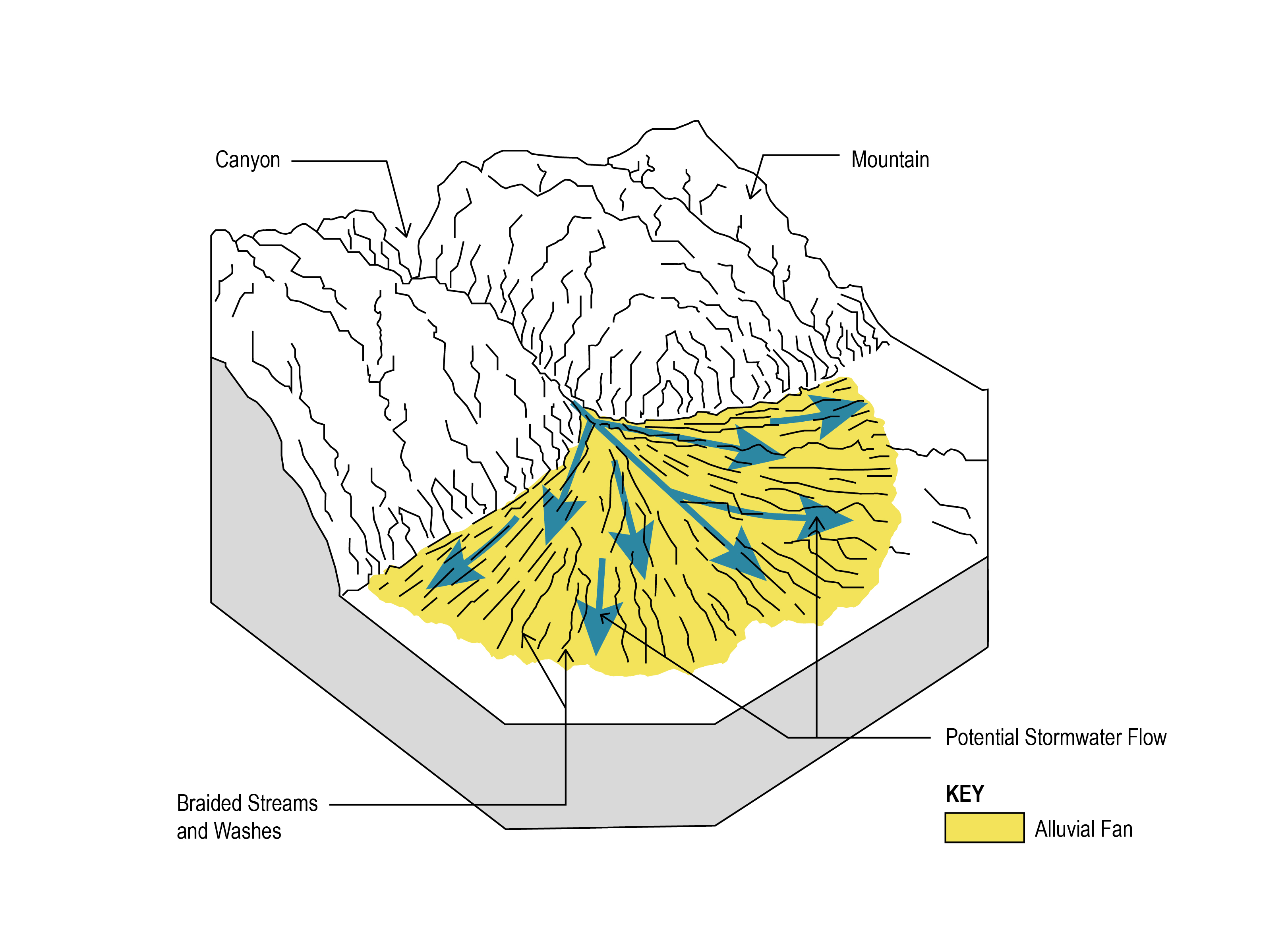
The Reata Wash floodplain poses significant flood risks to people, properties and infrastructure in north Scottsdale. The Reata Wash floodplain is a geologic alluvial fan feature where stormwater and sediment travel down irregular terrain and spread out unpredictably in a fan shape.
Properties and structures within the floodplain are at some risk of flooding from a major storm event. Flooding will vary depending on where the water spreads across the fan floodplain. In addition, several major transportation arterials – including Pima Road, Thompson Peak Parkway and Pinnacle Peak Road – are likely to be impassible and potentially damaged following a major storm.
Flood Control Gaps in Existing Infrastructure
Since the FEMA floodplain was designated, bridges, drainage and flood control structures have been built to reduce the risk of flooding. Despite these measures, “gaps” remain in the existing flood control infrastructure – in particular within the upper and lower portions of Reata Wash. Due to these gaps, additional FEMA-compliant solutions for reducing or eliminating the FEMA floodplain are needed.
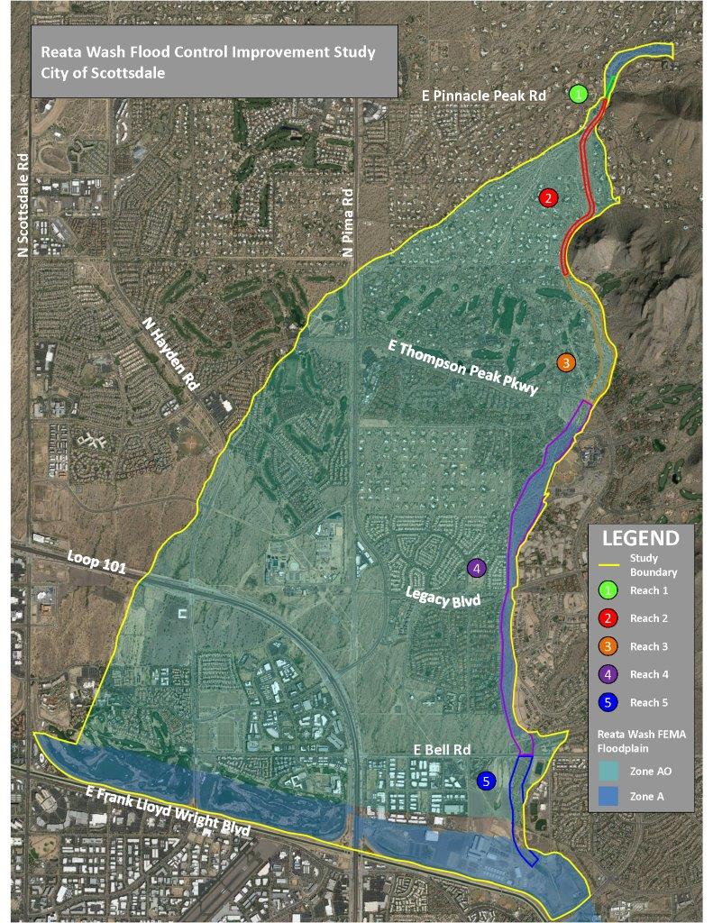
Reata Wash has been divided into five segments – or reaches – for the study. Flood mitigation measures will be evaluated and recommended in each segment based on existing drainage infrastructure and severity of the flooding predicted.
Study Recommended Solution
The recommended solution accomplishes the following study goals:
- Maximize use of existing stormwater infrastructure
- Comprehensive solution to satisfy FEMA regulations
- Compliance with anticipated environmental requirements
- Environment and landscape sensitive design
- Minimal land disturbance
- Less disruptive construction and shorter time to construct
- Cost-effective solution
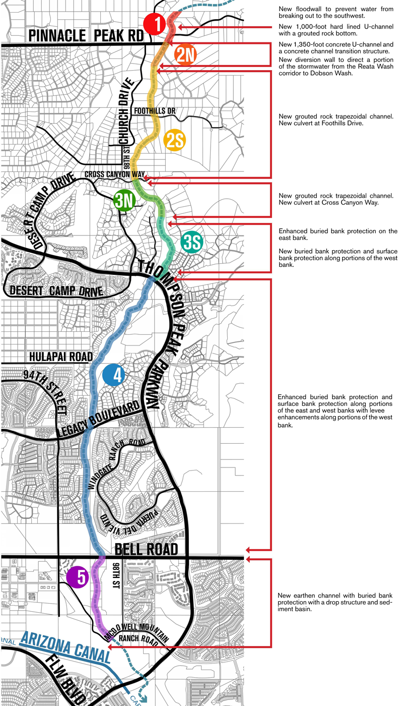
The recommended solution consists of a designated drainage corridor starting 1,000 feet north of Pinnacle Peak Road bridge and continues south to the Central Arizona Project (CAP) canal. A total of approximately 5.3 miles.
Beginning at the north, the recommended solution includes the following features:
Potential Alternatives to Recommend Solution
Potential alternatives to the recommended solution has also been prepared.
Alternative B consists of constructing a box culvert instead of the U-channel from the Pinnacle Peak Road Bridge to approximately 1,350 feet south.
Alternative C includes the alternative B changes, but extends the construction of a reinforced box culvert (instead of the U-channel and grouted rock channel) to 7,900 feet south of Pinnacle Peak Road or approximately 1,800 feet south of Cross Canyon Way.
Right-of-Way Impacts
Based on the 15% level design of the recommended solution, the City of Scottsdale has land rights for 279 acres (95.5%) of the 292 acres required to construct the recommended solution. To complete the comprehensive flood control solution, the city would need land rights for 13 acres (affecting nine property owners). Temporary construction and temporary access easements may also be required.
Benefit/Cost Analysis
The cost of the recommended FEMA compliant solution is approximately $48,210,000. This cost includes estimates for construction ($43,000,000), Clean Water Act (CWA) Section 404 mitigation ($1,710,000), and land rights ($3,500,000).
The Reata Wash Study utilized a benefit cost analysis to evaluate the potential project’s economic advantages (benefits) and disadvantages (costs). A project is considered to be cost-effective when the benefit cost ratio is 1.0 or greater, which indicates the benefits are greater than the cost.
Based on the annualized benefit of $3,702,818 and annualized cost of $1,779,354 the benefit cost ratio was determined to be 2.08, indicating the benefits of a potential flood hazard mitigation project are sufficient to justify consideration for a project.
Public involvement was a key element of this study. When asked in March 2016, 86% of the residents attending the public meeting felt it was important for the City of Scottsdale to identify potential solutions for reducing the risk of stormwater flooding for residents and businesses in the Reata Wash flood control study area. In addition, residents who attended HOA briefings supported the flood control study.
The City presented potential options for reducing stormwater flood risk at a second public
meeting in May 2016. Comments from this meeting were used to further refine the options and to develop a comprehensive flood control solution to convey stormwater within the entire Reata Wash designated corridor.
The city recognizes the unique desert environment in this area, all options are context-sensitive to be compatible with the surrounding environment as much as feasible. The city is not considering recreational or multi-use opportunities as part of any flood mitigation solution.
Community Meeting #2
Wednesday, May 18, 2016Public Meeting Presentation # 2
Presentation BoardsCommunity Meeting #1
Wednesday, March 2, 2016
Public Meeting Presentation #1
Several community and stakeholder meetings have been held throughout the course of the study. The study team will also meet with individual stakeholders, including homeowners’ associations, to review the options being considered.
Frequently Asked Questions
The City of Scottsdale is studying the Reata Wash floodplain to identify and recommend flood control measures to reduce flood risks to residents, property and public infrastructure. The Reata Wash floodplain encompasses a large area in north Scottsdale between approximately Pinnacle Peak Road and the Central Arizona Canal (CAP). See the study area map. Approximately 30 years ago, the Federal Emergency Management Agency (FEMA) designated the 100 year Reata Wash floodplain.
There are more than 4,600 residential, public facilities and commercial structures located within the floodplain at potential risk of flooding in accordance with FEMA guidelines. Property owners within the floodplain with a federally-backed mortgage are required to carry flood insurance through the National Flood Insurance Program (NFIP).
The study area boundaries are shown on the map. The study area generally corresponds to the existing Reata Wash FEMA regulatory floodplain, which is shaded in blue. Reata Wash – the watercourse that creates the floodplain – lies on the eastern boundary of the study area.
The purpose of the study is to identify and recommend flood control measures that will reduce flood risks to residents, property and public infrastructure. We will work with the community to develop a solution that is cost effective, sensitive to the environment, and compliant with federal regulations and guidelines.
A secondary goal is to remove or reduce the size of the current floodplain designation established by FEMA. This would eliminate or reduce the requirement for many property owners to purchase flood insurance through the NFIP. The floodplain re-mapping (known as re-delineation) would need to be conducted after flood control measures are constructed to demonstrate to FEMA that the current flood risk has been eliminated or reduced to specific properties in the floodplain.
The Reata Wash floodplain poses significant flood risks to people, properties and infrastructure in north Scottsdale. This is due to the geography of the area and the type of flooding that occurs here during storm events. The Reata Wash floodplain is a geologic alluvial fan feature where stormwater and sediment travel down irregular terrain and spread out unpredictably across the fan depositing sediment.
Properties & structures within the floodplain are at risk of flooding from a major storm event. Flooding will vary depending on where the water spreads across the floodplain fan. In addition, several major transportation arterials – including Pima Road, Thompson Peak Parkway and Pinnacle Peak Road – are likely to be impassible and potentially damaged as the result of a major storm.
Stormwater flows in Reata Wash travel at high speeds from nearby mountains and are concentrated through narrow washes at the upper portion of the wash. During a 100-year storm event (approximately 4-5 inches of rainfall in less than 24 hours), it is anticipated that 13,000 cubic feet of water per second will flow down from the mountains and travel through Reata Wash near Pinnacle Peak Road.
As the water moves downstream the land flattens, causing the water to spread out over larger areas. Within an alluvial fan floodplain the channels are shallow which allows the water to break out of the channel banks and create new channels.
Stormwater flows do not distribute evenly across the fan during any storm. The locations where water breaks out of the channel will determine which of the structures in the floodplain would be at risk from flooding during an individual storm. Each storm could result in a different water flow, causing different areas of the floodplain to be at risk.
Since the FEMA floodplain was designated, bridges, drainage and flood control structures have been built to reduce the risk of flooding. Despite these measures, “gaps” remain in the existing flood control infrastructure – in particular within the upper and lower portions of Reata Wash. Due to these gaps, additional FEMA-compliant solutions for reducing or eliminating the FEMA floodplain are needed.
Reata Wash has been divided into five segments – or reaches – for the study. Flood mitigation measures will be evaluated and recommended in each segment based on existing drainage infrastructure and severity of the flooding predicted. The city recognizes the unique desert environment in the study area, and any options that would be considered would be context-sensitive to be compatible with the surrounding environment as much as feasible. The city is not considering recreational or multi-use opportunities as part of any flood mitigation solution.
While other parts of the Phoenix metropolitan area had flooding in the historic August and September 2014 storm events, it may surprise you to learn that these were not 100-year storms in the Reata Wash area. A 100-year storm has a 1 percent chance of occurring in any given year and is the equivalent of approximately 4-5 inches of rainfall in less than 24 hours. The rainfall recorded in Reata Wash during the September 8, 2014 storm was 2.28 inches, which is the equivalent of approximately a 25-year storm event. There has not been 100-year storm rainfall levels recorded in the study area since rain gages were installed approximately 14 years ago.
Due to the type of flooding in Reata Wash, FEMA will likely not approve re-mapping the floodplain (known as re-delineation) until flood control measures are constructed to demonstrate to FEMA that the current flood risk has been eliminated or reduced to specific properties in the floodplain. It is anticipated that flood control measures would remove the majority of the existing FEMA floodplain designation. Owners whose properties are no longer located in the floodplain may not be required by their mortgage company to carry flood insurance through the National Flood Insurance Program (NFIP). However, floodplain re-mapping is a lengthy process that can take several years for FEMA to complete.
The City of Scottsdale elects to participate in the NFIP sponsored by FEMA. The NFIP provides affordable, federally-subsidized flood insurance for property owners. As a condition to participate in the program, local communities must adopt and enforce floodplain management regulations to reduce or avoid future flood losses by FEMA. These regulations help mitigate flooding to new and improved structures, as well as to existing adjacent properties within the floodplain. This is accomplished through special building permit requirements for properties in the floodplain, maintenance of existing city-owned drainage, and enforcement. The city is not involved in flood insurance programs, including setting flood insurance premium rates.
Structures that are located within a FEMA designated floodplain and have a federally-insured mortgage, are required (as part of the NFIP program) to purchase flood insurance. This requirement is administered through their lending institution. It should be noted that some lending institutions require insurance for properties not located within a designated FEMA floodplain. The NFIP has an appeal process that provides flood insurance policyholders with the option to dispute a decision. The City of Scottsdale Stormwater Management Office can also be contacted to determine if an elevation certificate is on record for the structure. In order to advance an appeal, the appeal must be based on new technical information that is FEMA compliant.
The city often partners with the Flood Control District of Maricopa County (FCDMC) to conduct Area Drainage Master Studies which identify the flooding risks within watersheds. The Pinnacle Peak West Area Drainage Master Study (led by the FCDMC) is evaluating potential flood control options for flooding hazards identified in the Rawhide Wash floodplain located just west of the Reata Wash floodplain.
Public involvement will be a key element of this study. Affected residents will be invited to participate in the study and help evaluate potential alternatives. Community and stakeholder input will be used to help decide which flood control mitigation measures are best suited for each portion of Reata Wash. The city recognizes the unique desert environment in this area, and any options that would be considered would be context-sensitive to be compatible with the surrounding environment as much as feasible. The city is not considering recreational or multi-use opportunities as part of any flood mitigation solution.
Several community and stakeholder meetings will be held throughout the course of the study. The study team will also meet with individual stakeholders, including homeowners’ associations, to review the options being considered.
Glossary of Terms
Federal Emergency Management Agency (FEMA) provides the following definition: The term "100-year flood" is used in an attempt to simplify the definition of a flood that statistically has a 1 percent chance of occurring in any given year.
The Arizona Department of Water Resources (ADWR) provides the following definition: 1-Percent-Annual Chance Flood: The flood that has a 1 percent chance of being equaled or exceeded in any given year.
Federal Emergency Management Agency (FEMA) provides the following definition: Flooding occurring on the surface of an alluvial fan or similar landform which originates at the apex and is characterized by high-velocity flows, active processes of erosion, sediment transport, and deposition, and unpredictable flow paths.
Arizona Department of Water Resources (ADWR) provides the following definition: Flooding that occurs only on alluvial fans and is characterized by flow path uncertainty so great that this uncertainty cannot be set aside in realistic assessments of flood risk or in the reliable mitigation of the hazard. An active alluvial fan flooding hazard is indicated by three related criteria: (1) flow path uncertainty below the hydrographic apex; (2) abrupt deposition and ensuing erosion of sediment as a stream or debris flow loses its ability to carry material eroded from a steeper, upstream source area; and (3) an environment where the combination of sediment availability, slope, and topography creates an ultra-hazardous condition for which elevation on fill will not reliably mitigate the risk.
Zone AO depicts a certain type of flooding (alluvial fan flooding) on a Flood Insurance Rate Map (FIRM), and is shown along with a flood depth and velocity. Therefore a flood zone of A03 means an average flood depth of 3 feet is occurring in that portion of the fan. A velocity measured in feet per second (fps) is also displayed on flood insurance maps in conjunction with a flood zone. Within Reata Wash, the following flood zones are in place: Zone AO and Zone A. Within the AO flood zone, there are three sub-zones: Zone A03 with a velocity of 8 fps and 9 fps, Zone A02 with a velocity of 6 fps and 7 fps, and Zone A01 with a velocity ranging from 3 fps to 5 fps. The deeper, faster-moving flood waters occur in the upper fan area near Pinnacle Peak Road. The shallower, slower moving flood waters are found downstream as the fan spreads out. In Zone A, no flood depths are shown because detailed hydraulic analyses have not been performed in these areas. However, these areas are subject to inundation by the 1-percent-annual-chance flood event generally determined using approximate methodologies.
Conditional Letter of Map Revision (CLOMR) is a Federal Emergency Management Agency (FEMA) decision to a community request for FEMA’s approval regarding proposed alterations to the floodplain delineation within the community. The CLOMR documents and describes the effect of the proposed project, if constructed as proposed, on the effective or current FEMA floodplain delineations. A CLOMR contains detailed information on conditions that must be met by the community before FEMA will issue a final determination regarding revising the effective or current FEMA floodplain delineations.
Letter of Map Revision (LOMR) is an official determination by Federal Emergency Management Agency (FEMA) that a property has been removed from the effective or current floodplain delineation. Removal of property is generally based on placement of earth fill, construction of levees or other flood control structures, or more advanced technical information applicable to the watershed creating the FEMA floodplain. Upon satisfying FEMA requirements, an approval letter is issued by FEMA.
| ADWR | Arizona Department of Water Resources |
| CFS | Cubic Feet Per Second |
| CLOMR | Conditional Letter of Map Revision |
| FCDMC | Flood Control District of Maricopa County |
| FEMA | Federal Emergency Management Agency |
| FIRM | Flood Insurance Rate Map |
| FPS | Feet Per Second |
| LOMA | Letter of Map Amendment |
| LOMR | Letter of Map Revision |
| NFIP | National Flood Insurance Program |
| PPS ADMS | Pinnacle Peak South Area Drainage Master Study |
Project Information
Budget: $2,256,000
Sponsoring Division: Stormwater & Floodplain Management
Funding Source: General Fund
Contact Information
7447 E. Indian School Road
Scottsdale, AZ 85251
P: 480-312-7250
Get Involved
Receive updates and community meeting notices as the project moves forward.
Project Newsletter Subscription
If you have a comment or question, please call the project hotline at 480-312-7328.
Overall Plan

Final Design Concept Report
- Volume I – Executive summary, chapter summaries, study conclusion
- Volume II – Exhibits
- Volume III – Appendices A - C
- Volume III – Appendices D (Part 1)
- Volume III – Appendices D (Part 2)
- Volume III – Appendices E
- Volume III – Appendices F - H
- Volume III – Appendices I - M
- Volume III – Appendices N - O
- Volume III – Appendices P - S